


There’s a tiny bit of good news and a lot of bad news for Louisiana contained in the rollout of a nonprofit’s new database of flood risk for more than 142 million homes and properties in the U.S.
First, the good news: The Flood Factor database created by First Street Foundation found that, while federal flood maps show 561,000 properties at substantial risk today in Louisiana from a flood event caused by rainfall, river flooding or hurricane storm surge, that's an overcount. The real number is actually about 477,100 properties.

Because of increasing rates of sea level rise fueled by global warming, the remaining 5,800 square miles of Louisiana's coastal wetlands in th…
Now, the bad: Louisiana ranked No. 2 in the nation in terms of the proportion of properties with substantial flood risk, at 21.1%. That was behind West Virginia, at 24.4%, and just ahead of Florida at 20.5%.
The even worse news is that 2050 – when a typical 30-year mortgage signed today would expire -- the number of properties considered at substantial risk of flooding in Louisiana will have increased by 70%, to 809,800 statewide. That's by far the largest increase in flooding risk of any state.
Delaware will have the second-greatest increase in risk, with a 21% increase, followed by New Jersey, at 19.1%.
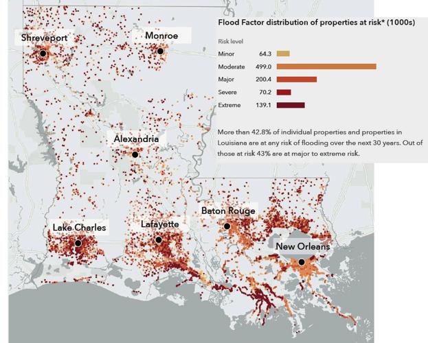
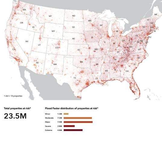
The study defines substantial flood risk as a centimeter or more of water inundation in a building within a 100-year return period, the equivalent of 1% risk per year.
The online database and visualization tool provides information on past, present and future flood risk and information about recent and projected environmental changes contributing to it.
The model looks at inundation data from river water, rainfall, storm surge and tides, and develops scenarios to represent floods, ranging from biennial events to less frequent 1-in-500-year events, occurring today and at five-year intervals into the future.
In Louisiana, most of the 30-year increase will result from rising sea levels caused by global warming that will result in higher storm surges, from high tides increased by sea-level rise, and by flood events triggered by increased rates of rainfall.

A new state task force has been given a deadline of 12 to 18 months to come up with a science-based comprehensive strategy to reduce greenhous…
Nationwide, the database found that while FEMA has identified 8.7 million properties as at substantial risk of a flood during the next 30 years, the new database identified almost 70% more were at risk, or 14.6 million properties.
Louisiana’s lower numbers today are the result of flood maps not being updated to take into account the protection provided by levees and other projects built since the maps were last published, said Mike Amodeo, director of data science with First Street.
Nationwide, the dramatic increase in the number of properties at risk owes to data issues with existing FEMA flood maps, ranging from delays in their revision to a lack of adequate data concerning the effects of river flooding, and to the present and future effects of sea-level rise and other weather and water changes resulting from climate change.
The study separately weighs the potential of properties facing a greater, 500-year level, of flood risk, equivalent to a 0.2% chance of flooding each year, and finds that New Orleans ranked worst in the nation, with 98% of its properties at risk both today and in 2050.
That’s because the area’s post-Katrina levee system provides protection from flooding only from a 100-year event, and, if not improved, will provide less protection than that in the future.
A map of Louisiana showing where that 500-year level of risk exists indicates hotspots of moderate to extreme risk in the regions surrounding New Orleans, Baton Rouge, Lafayette and Lake Charles, and on the north shore, mostly because of expected increases in sea-level rise and storm surges. Smaller pockets of increased risk are in the Monroe and Shreveport areas.
Bren Haase, executive director of Louisiana's Coastal Protection and Restoration Authority, which oversees coastal flood risk mitigation efforts, said the report uses a similar method of identifying coastal flood risk as used by the state, but "at a much coarser scale and may not incorporate some flood-protection measures we know are in place."

Punching two more holes in the sides of the Mississippi River could reduce New Orleans’ flood risk while easing the environmental harm caused …
He said the state may look into incorporating the database information on combined risk of rainfall, riverine and coastal flooding into its own analyses, including ongoing interior flood risk planning taking place under the state's Louisiana Water initiative.
A spokesman for the New Orleans office of the Army Corps of Engineers, which oversees much of the flood reduction planning along the coast and along rivers, said the agency hasn't evaluated the report or its methodology, and was unable to comment on its findings.
Nationwide, the study identified 23.5 million properties as at-risk over the next 30 years, including 3.6 million it said were “facing almost certain risk, with a 99% chance of flooding at least once over the next 30 years.”
Among major cities, New Orleans ranked third in the absolute number of properties at substantial risk, with 148,197 in that category. Only 35 additional properties would be added to that risk in 30 years, because the study found that 98% of existing properties are already at risk.
Houston ranked first in risk today, with 186,481 properties at risk, and 202,317 at risk in 2050. Chicago ranked second, with 154,824 properties at risk today, and 160,068 in 2050. Those cities, of course, are far larger than New Orleans, meaning the relative risk here is much higher.
The flood risk database was created by First Street Foundation, with the assistance of Columbia University; Fathom; George Mason University; Massachusetts Institute of Technology; Rhodium Group; Rutgers University; The University of California, Berkeley; and University of Bristol.
The database found that only Louisiana, Arizona and New Jersey had lower counts of properties now at substantial risk than what FEMA Special Flood Hazard Area maps show.

The Mississippi River in New Orleans has dropped below 11 feet at the Carrollton Gauge for the first time in nearly six months, ending Army Co…
A report released by First Street to explain the database says its creators expect its findings can be used by individuals, the investment community and by governments to make policy changes addressing future flooding.
For individuals, that might include recognition of the need to mitigate flood risk by buying insurance, finding alternate places to live or build, or modifying existing properties.
For real estate, mortgage, insurance and investment businesses, it might include using the data to address risk issues, including risk estimates for buildings and structures.
Federal, state and local government officials might use the database in developing adaptation strategies including buyout programs, construction of new flood-fighting public works, or to modify existing infrastructure.

The Mississippi River likely won’t be lapping a few feet from the tops of New Orleans levees like it did last hurricane season, offering welco…
Mark Schleifstein covers the environment and is a leader of the Louisiana Coastal Reporting Team for The Times-Picayune | The New Orleans Advocate. Email: mschleifstein@theadvocate.com. Facebook: Mark Schleifstein and Louisiana Coastal Watch. Twitter: MSchleifstein.


