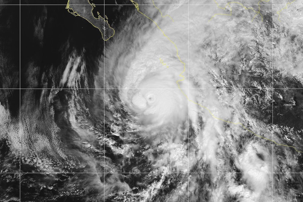
On Monday morning, a mild tropical storm in the Pacific Ocean heading toward Mexico’s western coast suddenly transformed into one the strongest tropical cyclones ever to threaten the region. Hurricane Willa—which had maximum sustained winds of 40 miles-per-hour less than 48 hours prior—had quadrupled in intensity, gusting at 160 miles-per-hour.
Residents of the Mexican states Sinaloa and Nayarit must now scramble to prepare for a Category 5 storm they didn’t realize was coming. Expected to make landfall there on Tuesday afternoon, Willa is now threatening “life-threatening flash flooding and landslides,” “dangerous storm surge,” and “large destructive waves,” according to the National Hurricane Center.
Willa’s unexpected growth has been both “explosive” and “extremely impressive,” the NHC said. But it’s also eerily familiar. Willa is the third devastating hurricane in the last month to experience “rapid intensification,” a phenomenon in which a hurricane’s sustained wind speeds increase by at least 35 miles-per-hour over a 24-hour period.
Explosive rapid intensification from low-end tropical storm to Category 5 hurricane in 48 hours -- zooming in on the core of #Willa pic.twitter.com/4XJ9aASOuS
— Stu Ostro (@StuOstro) October 22, 2018
Hurricane Michael was the last to catch meteorologists off guard. It was only a Category 1 storm on October 8, less than two days before it made landfall as nearly a Category 5, one of the strongest hurricanes ever to make landfall in the United States. Hurricane Florence jumped from a Category 2 to Category 4 storm in a period of a few hours before it slammed into North Carolina in September. The trend isn’t limited to this year, either. The most destructive and infamous storms of 2017—Hurricanes Harvey, Irma, Jose and Maria—all underwent rapid intensification, according to The Washington Post.
It’s fairly normal for hurricanes to gain strength over short periods of time, but rapid intensification is becoming more severe. “A study in the journal Geophysical Research Letters found that the magnitude of these rapid intensification events increased from 1986 to 2015 in the central and eastern tropical Atlantic Ocean,” the Post noted. “From 1986 to 2000, the average storm that rapidly intensified saw its peak winds increase by 32 mph in 24 hours, but the increase was 36 mph in 24 hours from 2001 to 2015.”
It’s also abnormal—and far more dangerous—when hurricanes undergo rapid intensification right before they make landfall, thus leaving less time for people to prepare. The fact that this happened twice in a row with Michael and Florence was “unusual,” Corene Matyas, a climatologist at the University of Florida in Gainesville, told NBC News in mid-October.
Remarkable comparison of the rapid intensification of Hurricanes Michael & Harvey.
— Dakota Smith (@weatherdak) October 14, 2018
Both occurred just prior to landfall. pic.twitter.com/gfYuAudEQI
But the conditions were right for Michael to strengthen close to landfall, Matyas said, citing abnormally warm water running abnormally deep. Those conditions are becoming more common. “As the world continues to warm from the increase in greenhouse gases, the coming decades are likely to bring hurricanes that intensify even more rapidly,” reads a report from the non-profit Climate Central.
In other words, Willa’s rapid intensification may represent the third sucker-punch storm in a row this year. But as long as we remain on a course of increasing carbon emissions, we should expect to keep getting hit.
